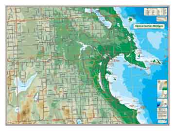
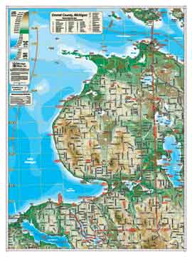
Alpena County, MI
A dramatic looking map with the great mouth of Thunder Bay the dominating feature of Alpena's Lake Huron shoreline. The valley of the Thunder Bay River dominates the land features where it originates from the northern highlands. An interesting feature of this map are the many shipwrecks noted along the coast and clustered around the North Shore and aptly named Misery Bay.
Giclee print on acid-free premium coated stock.
Item# – AAPR18 – 24" x
18"
Item# – AAPR27 – 36" x 27"
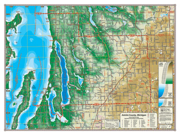
Antrim County, MI
This beautiful map displays the physical features of Antrim County and its environs in dramatic color. Our coverage runs the length of the county, from the detailed lake depths of Grand Traverse Bay to the striking relief topography of the eastern hills. The Elk River watershed and the Antrim Chain of Lakes are also featured, including their depths down to the 300-foot Torch Lake.
Giclee print on acid-free premium coated stock.
Item# – ANPR18 – 24" x
18"
Item# – ANPR27 – 36" x 27"
See Pricing & Specs Below
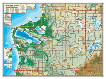
Benzie County, MI
Benzie County is shown here in beautiful relief with all its features: the Sleeping Bear National Lakeshore, the Platte River and Betsie River valleys, Crystal, Platte, and Little Platte Lake. All major lakes, including Lake Michigan, are shown with detailed depths.
Giclee print on acid-free premium coated stock.
Item# – BZPR18 – 24" x
18"
Item# – BZPR27 – 36" x 27"
See Pricing & Specs Below
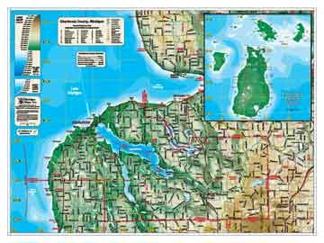
Charlevoix County, MI
This beautiful map displays the physical features of Charlevoix County and its lakes in dramatic color. The change in elevation from the eastern highlands, to the Charlevoix and Walloon Lake basins, and the Lake Michigan shoreline, make for a specially colorful map. The map includes an inset depicting Beaver Island and other islands in in the Charlevoix archipelago.
Giclee print on acid-free premium coated stock.
Item# – CVPR18 – 24" x
18"
Item# – CVPR27 – 36" x 27"
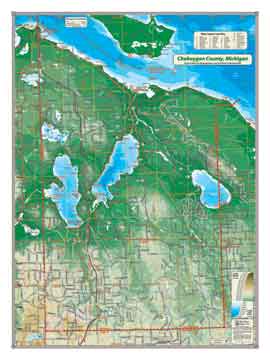
Cheboygan County, MI
This map covers Cheboygan County from the Straits of Mackinac as it rises into the central highlands. Cheboygan includes the three largest lakes in the Inland Waterway, Mullet, Burt and Black, in addition to Douglas Lake, all shown with depths. The picturesque Huron shoreline tops off this beautiful map and includes most of Bois Blanc island (although the island is actually part of Mackinac Island).
Giclee print on acid-free premium coated stock.
Item# – CBPR18 – 18 " x
24 "
Item# – CBPR27 – 27 " x 36 "
See Pricing & Specs Below
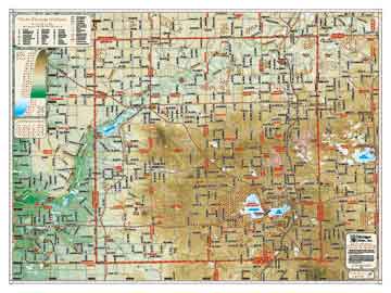
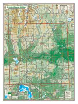
Crawford County, MI
Crawford County sits in the middle of it all. Nestled in the center of the northern highlands, two great river valleys originate in these hills: the Manistee River flowing to the west and the Au Sable river flowing to the east. This map also covers Higgins Lake which abuts the southern boundary of the county.
Giclee print on acid-free premium coated stock.
Item# – CWPR18 – 18 " x
24 "
Item# – CWPR27 – 27 " x 36 "
See Pricing & Specs Below
Emmet County, MI
This map covers Emmet County from the Straits of Mackinac beyond the Charlevoix County line. Lake Michigan is shown with lake depths, and the map includes adjacent lakes, such as Burt, Douglas, Walloon and Lake Charlevoix. Dramatic changes in elevation from the highlands to the lakeshore make this a beautiful and striking map.
Giclee print on acid-free premium coated stock.
Item# – EMPR18 – 18 " x
24 "
Item# – EMPR27 – 27 " x 36 "
See Pricing & Specs Below
Grand Traverse County, MI
This map shows all of Grand Traverse County, including Old Mission Peninsula and the Boardman River valley. The east and west arms of Grand Traverse Bay are shown with lake depths, as are Long Lake, Green Lake, and Duck Lake. The detailed and colorful topography of the hills of Grand Traverse County make this a beautiful and striking map.
Giclee print on acid-free premium coated stock.
Item# – GTPR18 – 18 " x
24"
Item# – GTPR27 – 27 " x 36 "
See Pricing & Specs Below

Kalkaska County, MI
From the shorelines of Torch Lake, Skegemog Lake and Torch River to the eastern glacial moraines, Kalkaska County map is depicted in 20 meter relief. This beautiful map dramatizes Kalkaska scenic ridges and describes the wild and less well known Manistee River valley.
Giclee print on acid-free premium coated stock.
Item# – KLPR18 – 24" x
18"
Item# – KLPR27 – 36" x 27"
See Pricing & Specs Below
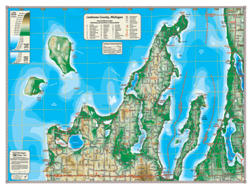
Leelanau County, MI
Our coverage of Leelanau County is depicted in colorful relief and includes North and South Manitou Islands, the Sleeping Bear National Lakeshore with Pyramid Point and Sleeping Bear Point, and major lakes displayed with lake depths, including Big and Little Glen Lakes, North Lake Leelanau and South Lake Leelanau. Lake Michigan is also shown with depths, from Good Harbour Bay around the peninsula to Grand Traverse Bay.
Giclee print on acid-free premium coated stock.
Item# – LEPR18 – 24" x
18"
Item# – LEPR27 – 36" x 27"
See Pricing & Specs Below
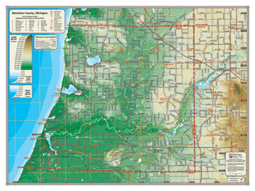
Manistee County, MI
All of Manistee County is depicted in this beautiful map, from the Lake Michigan shoreline (shown with lake depths) up the Manistee River valley to Tippy Dam and the Tippy Dam Pond. Bear, Portage, and Manistee Lakes are displayed along with their depths, as well as all the topographical relief of the county.
Giclee print on acid-free premium coated stock.
Item# – MEPR18 – 24" x
18"
Item# – MEPR27 – 36" x 27"
See Pricing & Specs Below
Missaukee County, MI
Missaukee County dips into the Manistee River valley in the northeast, but most of the county's terrain drains into the Muskegon River and makes up the headwaters of that great river—all depicted in 20 meter relief. Also depicted on this colorful map with depths is Lake Missaukee. Map coverage extends from Lake Mitchell to Houghton Lake.
Giclee print on acid-free premium coated stock.
Item# – MKPR18 – 24" x
18"
Item# – MKPR27 – 36" x 27"
See Pricing & Specs Below
Otsego County, MI
Otsego County sits astride the central highlands of the northern Lower Peninsula. Depicted in 20 meter relief, map coverage extends from the US-131 corridor on the west to the Twin Lakes on the east.
Giclee print on acid-free premium coated stock.
Item# – OOPR18 – 24" x
18"
Item# – OOPR27 – 36" x 27"
See Pricing & Specs Below

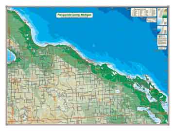
Presque Isle County, MI
Presque Isle County's long Lake Huron shoreline dominates this map and creates a striking contrast to the interior highlands. Coverage area ranges from Black Lake on the west to Long Lake on the east. Land relief is depicted in 20 meter relief. Lake Huron is shown in depths.
Giclee print on acid-free premium coated stock.
Item# – PIPR18 – 24" x
18"
Item# – PIPR27 – 36" x 27"
See Pricing & Specs Below
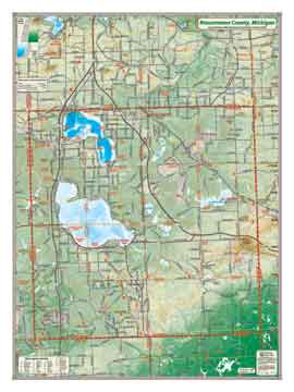
Roscommon County, MI
The home county to Houghton Lake (the largest inland lake in Michigan by area) and Higgins Lake, Roscommon includes two important Federal interstate corridors: I-75 and 127. Inland lakes are shown with depths, land forms in physical relief.
Giclee print on acid-free premium coated stock.
Item#– ROPR18 – 24" x
18"
Item# – ROPR27 – 36" x 27"
See Pricing & Specs Below
Wexford County, MI
With the highest elevations in northwest Michigan and the breathtaking Manistee River valley, Wexford County contains some of the best raw material for a beautiful relief map. Also depicted, with depths, are Lakes Mitchell and Cadillac and the Hodenpyl Dam Pond. Like our other county maps, the Wexford map includes adjacent areas such as Lake Missaukee and Tippy Dam Pond.
Giclee print on acid-free premium coated stock.
Item# – WXPR18 – 24" x
18"
Item# – WXPR27 – 36" x 27"
See Pricing & Specs Below